
Just after the end of the American Revolution, wealthy Albany attorney Peter W. Yates began building a house for himself on Washington Street (later South Pearl Street), just north of the Beaverkill ravine. This elegant mansion was surrounded by orchards and gardens. To the east of the mansion was a grove of ash trees, which flanked the long drive from the house’s entrance to the street. The 1794 DeWitt map shows the location and basic configuration of the house and grounds.

In 1809, Yates sold his estate to James Kane, a prominent Albany merchant. In the course of Kane’s occupancy, the city expanded rapidly southward. As it did, Kane subdivided some of his lands for development. At some point in the 1820’s, Broad Street was extended southward, cutting off the mansion from the ash grove and from South Pearl Street. Kane had the grove surrounded by an iron fence with a pillared gateway at the entrance, and laid out footpaths inside the fence, turning the entire block into a semi-private park that came to be known as Kane’s Walk.
Kane’s Walk was later described as a ‘promenade for the fashionable and wealthy’ and a tree-filled ‘breathing spot,’ in the midst of the city.

Into the 1830’s, Kane’s Walk took on more of the character of a public park. A religious revival conducted by the ‘common preacher’ was held here in 1837. In the same year, the Common Council had to take action to prevent an ‘unauthorized’ circus from doing business at Kane’s Walk; but in the summer of 1850, the James M. June & Co. Circus had evening performances there. It was the location of the Albany public schools’ ‘Anniversary’ celebrations in the 1840’s and 1850’s, when upwards of 2,000 students from all of the city’s public schools would gather for speeches, declamations by pupils, and music.
Kane’s Walk also had its seedier side. Jesse Strang and Elsie Whipple, of Cherry Hill Murder fame, had a tryst here in 1827, as they conspired to murder Elsie’s husband. In December 1838, Rensselaer Van Rensselaer (son of Solomon, another resident of Cherry Hill) was violently assaulted by two men at Kane’s Walk. In August 1853, the body of an abandoned infant was discovered in the park. Two vagrants found sleeping in the Walk were arrested in June 1858. And in June 1860, Alwilda Hoffman and Ellen McCarty, both 15 years old, were arrested while ‘on a cruise’ in the company of several young men at Kane’s Walk.
Henry Yates, who had bought the Kane mansion in 1834, died in 1854, and shortly after, it was announced that Kane’s Walk would be subdivided and sold for development. It’s not clear how quickly this development took place – there was a school celebration in 1856, and the vagrants were arrested there in 1858. But references to Kane’s Walk seem to refer more and more to a locale rather than to an actual park. When the China Tea Shop advertised in 1861 that it was on ‘old Kane’s Walk,’ it was describing an address about a block north of where the park was located. In any event, an 1876 map shows the area formerly occupied by Kane’s Walk to be completely covered with buildings, both residential and commercial.

When word came that Kane’s Walk would be sold to developers, both the Evening Journal and the Argus, which usually agreed on nothing, advocated that the city purchase the block and turn it into a public park. The Evening Journal noted the need for such a park, since, of Albany’s four public parks, the one at Clinton Square was ‘continually closed,’ and ‘Van Rensselaer Park on Washington Street’ had been ‘left to decay.’ (The other two parks were Capitol Park and Academy Park.) Alas, the proposal was not acted upon and that area of the South End is still without a significant green space.
I was not able to find many images of Kane’s Walk (online, at least). There is a painting at the Seward House Museum in Auburn, NY entitled ‘Kane’s Walk,’ which Governor Seward had commissioned while he lived at the Kane Mansion. But the painting seems to show the house rather than the adjacent grove.

A very interesting image comes from a cartoon printed in about 1840. It depicted Thurlow Weed and Governor Seward and other members of the newly elected administration. The setting for the cartoon was Kane’s Walk. One can see the Kane Mansion in the distance, but in the foreground, the grove of trees, benches, footpaths, as well as a fence and gate. This may well be the best image we have of the Park That Might Have Been.
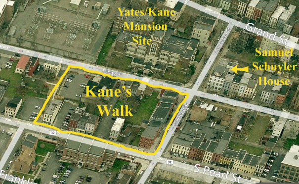
Today, what was Kane’s Walk is the block bounded by South Pearl Street on the east, Trinity Place (formerly Broad Street) on the west, extending from Westerlo Street southwards to a line opposite South Ferry Street. Here is a modern day aerial view. The Kane’s Walk area is in the center of the photo, with the old Philip Schuyler school on the location of the Yates/Kane mansion itself, and the Samuel Schuyler house just catty-corner from the northwestern edge of Kane’s Walk.

One thought on “Kane’s Walk: The Park That Might Have Been”